Skip to main content
{ Archipelago Commons 1.4.0 Live }
Unfailingly kind
Main navigation
Browse Digital Objects
Advanced Search
Extracted Text Discovery
Search inside Web Archives
Search inside Book/Document Pages
Support
Fulltext search
User account menu
Log in
(-)
historical geography
(-)
Historical geography--Maps
Displaying results 1 - 1 of 1
Advanced Fulltext search
Operator
Contains all of these words
Contains any of these words
Contains none of these words
Search Field
Rendered HTML Output
Title (full text)
Names/Agents
Local Identifier
Advanced Fulltext search
Operator
AND
OR
Operator
Contains all of these words
Contains any of these words
Contains none of these words
Search Field
Rendered HTML Output
Title (full text)
Names/Agents
Local Identifier
add
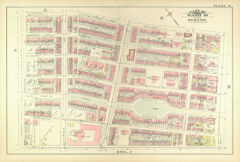
Atlas of the City of Boston, Volume 1 (1883): Plate N: part of ward 18; South End, Columbus Avenue, Chester Square
Map
Description
page, Plate N: part of ward 18; scale 100 feet per inch; South End, Columbus Avenue, Chester Square