Skip to main content
{ Archipelago Commons 1.4.0 Live }
Unfailingly kind
Main navigation
Browse Digital Objects
Advanced Search
Extracted Text Discovery
Search inside Web Archives
Search inside Book/Document Pages
Support
Fulltext search
User account menu
Log in
Description
Download
Metadata
MODS 3.7
Dublin Core
GeoJSON
IIIF Presentation Manifest 3.0
Images
139508_sv.jpg
Part of Collection
MIT Dome Digital Repository Demo Collection
Title
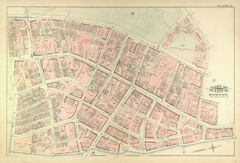
Atlas of the City of Boston, Volume 1 (1883)
Description
page, title page
Date Created
1883
Type
CreativeWorkSeries
Publisher
G.W. Bromley & Co.
Local Subjects
Cartography
Urban planning
Boston (Mass.)
Atlases
United States -- Maps
Fire insurance maps
Historical geography --Maps
City planning
Title pages
Language
English
Submitted by
carlj
on Wednesday, September 4, 2024 - 16:00.
Last modified
Thursday, October 3, 2024 - 12:28
Objects in this Series
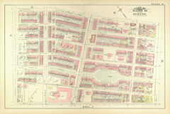
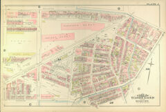
Atlas of the City of Boston, Volume 1 (1883): Plate N: part of ward 18; South End, Columbus Avenue, Chester Square
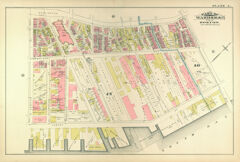
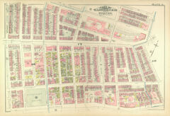
Atlas of the City of Boston, Volume 1 (1883): Plate L: part of wards 16 & 17; South End, Harrison Avenue, South Bay
Atlas of the City of Boston, Volume 1 (1883): Plate D: part of wards 7 & 8; West End
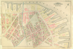
Atlas of the City of Boston, Volume 1 (1883): part of wards 6 & 7; North End, Hanover Street, Boston Harbor
Atlas of the City of Boston, Volume 1 (1883): Plate J; part of wards 11, 12 & 16; South End, Columbus Avenue
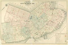
Atlas of the City of Boston, Volume 1 (1883): outline & index map of city of Boston proper; scale: 500 feet per inch
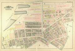
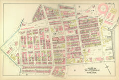
Atlas of the City of Boston, Volume 1 (1883): Plate O: part of wards 16, 17 & 18; South End, Tremont Street, Union Park,…
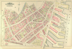
Atlas of the City of Boston, Volume 1 (1883): Plate K; part of wards 12 & 16, South End, New York streets
Atlas of the City of Boston, Volume 1 (1883): Plate A: part of wards 6 & 7; North End, Copps Hill Burying Ground
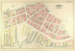
Atlas of the City of Boston, Volume 1 (1883): Plate H: part of ward 12; Fort Point Channel, Atlantic Avenue, waterfront
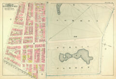
Atlas of the City of Boston, Volume 1 (1883): Plate Q: part of wards 9 & 10; Beacon Hill, Public Garden, Boston Common
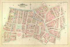
Atlas of the City of Boston, Volume 1 (1883): Plate F: part of wards 7, 9 & 10; Beacon Hill, State House, Pemberton Square,…
Atlas of the City of Boston, Volume 1 (1883):Plate G: part of ward 10; Downtown, Boston Common, Washington Street, Granary…